12 marks
State two differences between constructive and destructive waves
Did this page help you?
State two differences between constructive and destructive waves
Did this page help you?

Study Fig. 3.1, which is a photograph of a coastal area in Spain.
[1]
[2]
[3]
Did this page help you?

Describe the distribution of coral reefs shown in Fig. 3.2.
Did this page help you?
Study Fig. 3.1, which is a map showing the location of coral reefs around Martinique (an LEDC in the Caribbean).

[1]
[2]
[3]
Did this page help you?
Study Fig. 3.2, which is a photograph showing an area of coastline in the northwest of England.
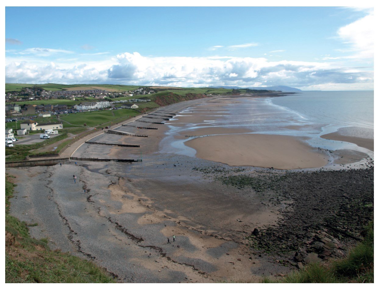
Describe and suggest reasons for the variation in beach material in the bay.
Did this page help you?
Study Photograph 3.1, which shows a beach where coastal deposition is taking place.

Did this page help you?
Study Photograph 3.2 (below), which shows an area where coastal erosion is taking place.

Give three pieces of evidence that coastal erosion has occurred in the area shown by Photograph 3.2.
Did this page help you?
Study Fig. 3.1 (below), which is a photograph showing an area where coastal erosion has taken place.

Did this page help you?
Study Fig. 3.2 (below), which is a photograph showing an area of mangroves.

Describe three characteristics of the mangroves shown in Fig. 3.2.
Did this page help you?
Study Fig. 4.1, which shows information about beaches at a coastal area in Norfolk, UK.
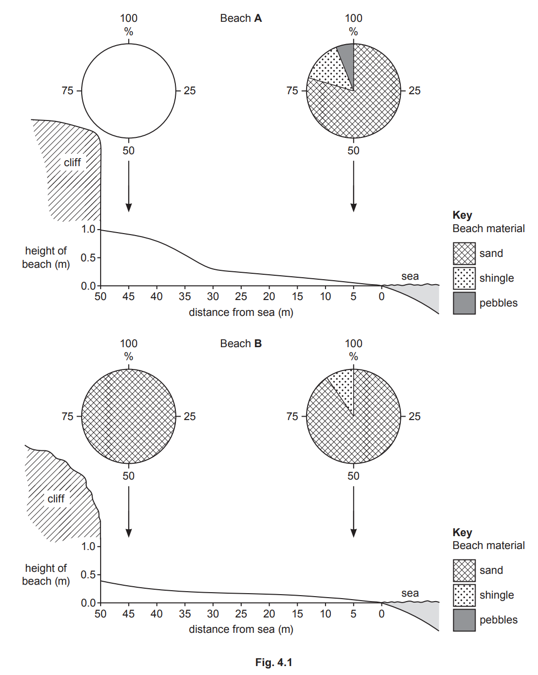
(i) Complete Fig. 4.1 to show the following information:
Beach A has 50% shingle and 50% pebbles next to the cliff.
[1]
(ii) Compare the material of Beach A and Beach B.
[3]
(iii) Identify two differences between the cross sections of Beach A and Beach B.
1 ........................................................................................................................................
2 ........................................................................................................................................
[2]
(iv) Explain why beaches consist of different materials.
[4]
Did this page help you?
Study Fig. 4.1, which shows Golden Bay on New Zealand’s South Island.

Fig.4.1
[1]
[2]
[3]
Did this page help you?
Study Figs. 4.2, 4.3 and 4.4 (Insert), which are photographs which show different features formed on a headland.

Fig.4.2
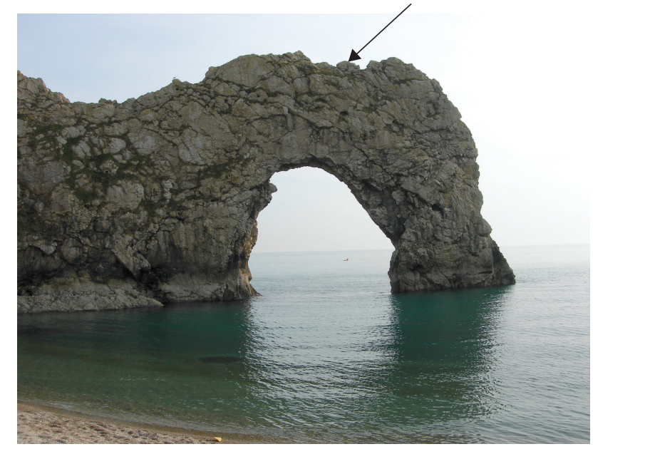
Fig.4.3

Fig.4.4
Identify the coastal landform shown by the arrows in each of Figs. 4.2, 4.3 and 4.4.
Fig. 4.2 .......................................................................................
Fig. 4.3 .......................................................................................
Fig. 4.4 .......................................................................................
Did this page help you?
For a named coastal area you have studied, describe attempts to manage erosion.
Did this page help you?
Describe the features of a sand spit and explain how it has been formed.
You may include a labelled diagram.
[7]
Did this page help you?
For a named area of coast you have studied, explain what is being done to manage coastal erosion.
Name of area ............................
[7]
Did this page help you?
For a named coastal area you have studied, describe the impacts of a tropical storm.
Name of coastal area .........................
[7]
Did this page help you?
For a named coastal area you have studied, describe how it is being protected from coastal erosion.
Name of area ..........................................
[7]
Did this page help you?
For a named coastal area you have studied, explain how coastal erosion has affected the people who live there.
Name of coastal area .................................................................
Did this page help you?
For a named area of coastline you have studied, explain how it provides opportunities for people.
Area of coastline ................................................
Did this page help you?
Explain how a wave cut platform is formed
Did this page help you?
Describe the conditions required for the development of coral reefs.
Did this page help you?
Study Fig. 3.2, which is a photograph showing an area of coastline in the northwest of England.
Suggest why bays and headlands have formed along the coastline shown in Fig. 3.2.
Did this page help you?
Study Photograph 3.2 (below), which shows an area where coastal erosion is taking place.
Explain why coastal erosion is much more rapid on some coasts than others.
Did this page help you?
Study Fig. 3.2 (below), which is a photograph showing an area of mangroves.
Describe the conditions which are required for the development of a mangrove swamp.
Did this page help you?
Study Fig. 4.2 (below), which is a photograph of an area of coastal sand dunes.

Suggest how the coastal sand dunes shown in Fig. 4.2 were formed.
Did this page help you?
Study Fig. 3.2, which is a photograph showing an area of coastline in the northwest of England.
Using evidence from Fig. 3.2, explain how coastal erosion has been managed.
Did this page help you?
Study Fig. 4.1, which shows Golden Bay on New Zealand’s South Island.
Fig.4.1
Suggest reasons why there are many beaches in Golden Bay.
Did this page help you?
Study Figs. 4.2, 4.3 and 4.4 (Insert), which are photographs which show different features formed on a headland.
Fig.4.2
Fig.4.3
Fig.4.4
Explain how coastal landforms on a headland, such as those shown in Figs. 4.2, 4.3 and 4.4, are formed by coastal erosion.
Did this page help you?