Rivers (CIE IGCSE Geography)

Topic Questions

1
Sme Calculator
5 marks

Study Fig. 3.1, which shows a river drainage basin.
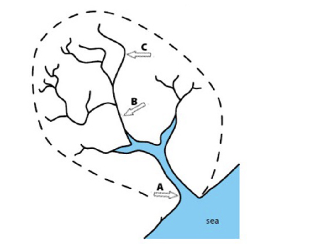
q1-2-2-paper-1-easy-cie-igcse-geography-tqs-

Fig. 1

(i)

Using Fig. 1, identify the following river features: 

A = …………………………… [1]

B = …………………………… [1]

C = …………………………… [1]

(ii)
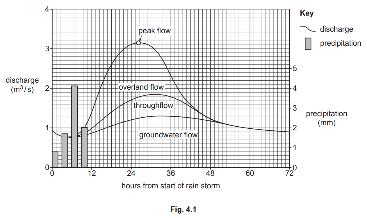
Identify the following hydrological processes which operate in a drainage basin. Choose your answers from the list below: 


evaporation

condensation

precipitation

interception

transpiration


1 – the change of water from a liquid to a gas (water vapour) due to heat from the sun ……………………………….

[1] 

2 – when plants release water vapour from their leaves ………………………………. 

[1]

Did this page help you?

2
Sme Calculator
4 marks

Suggest reasons why the amount of infiltration may vary 

Did this page help you?

3
Sme Calculator
6 marks

Study Fig. 3.1, which shows information about flows through a drainage basin.

q3a-nov-2020-paper-12-cie-igcse-geo
(i)
What is meant by transpiration?

[1]
(ii)
Explain why the amount of interception varies:
-  from place to place
-  at different times of the year.

[2]
(iii)
identify the processes which take place at X, Y and Z in Fig. 3.1.

X ........................................................................................................................................
Y ........................................................................................................................................
Z .......................................................................................................................................

[3]


Did this page help you?

43 marks

Study Figs. 3.3 and 3.4, which are photographs showing two different rivers and their valleys.

q3-3-3-insert-paper-12-cie-igcse-geo
Fig 3.3
q3-3-4-insert-paper-12-cie-igcse-geo

Fig 3.4

Describe the similarities and differences between the rivers shown in Figs. 3.3 and 3.4.

Did this page help you?

56 marks

Study Fig. 4.1, which is a hydrograph of a river after a rain storm.

q4a-0460-s20-qp-11
(i)

How long after the start of the rain storm is the peak flow?

..................................................................... hours
[1]
(ii)

Explain how water reaches a river from:

- throughflow ...................................................................................................................

- groundwater flow ..........................................................................................................
[2]
(iii)
Explain why the building of large settlements on or close to a flood plain increases the discharge of a river after heavy rain.
[3]

Did this page help you?

63 marks

Study Fig. 4.2,  which is a photograph of a river in an upland area.

fig-4-2-q4-0460-s20-in-11
Fig 4.2


Describe the main characteristics of the river and valley shown in Fig. 4.2.

Did this page help you?

74 marks

Study Fig. 3.1, which is a flow diagram showing processes in a drainage basin.

q3a-0460-s20-qp-13
(i)
What is a drainage basin?

 [1]

(ii)
Which of the following statements are correct?

 [2]

      Tick () two statements in the table below:    

  Tick ()
Overland flow occurs under the surface of the land.  
Water percolates from the surface into the soil.  
Groundwater flow moves water through the rocks.  
Water flows to the river on the surface by throughflow.  
Interception occurs when water vapour is evaporated.  
Infiltration occurs when water soaks into the soil.  

(iii)
Explain why overland flow may occur in a drainage basin.

[3]

Did this page help you?

83 marks

Study Fig. 3.2, which is a photograph showing a waterfall.

fig-3-2-q3-0460-s20-in-13
Figure 3.2 High Force, River Tees


Describe three features of the waterfall shown in Fig. 3.2.

1 ........................................................................................................................................

2 ........................................................................................................................................

3 ........................................................................................................................................

Did this page help you?

96 marks

Study Fig. 3.1, which shows different parts of a river and its valley.

qp-3a-0460-w19-qp-11
(i)
In which diagram, A, B or C, does the river valley have the steepest sides and narrowest valley floor?
[1]
(ii)
Which diagram is closest to the mouth of the river?
Give a reason for your answer.

Diagram chosen ....................

Reason for choice .....................
[2]
(iii)
Explain how erosion will take place along the river shown in Fig. 3.1.
[3]

Did this page help you?

103 marks

Study Figs. 3.2, 3.3 and 3.4, which are photographs of three different rivers.

f-g-3-2-q3-insert-0460-w19-in-11
Fig 3.2
f-g-3-3-q3-insert-0460-w19-in-11
Fig 3.3
f-g-3-4-q3-insert-0460-w19-in-11
Fig 3.4

Using evidence from Figs. 3.2, 3.3 and 3.4 only, describe three different benefits of lliving near a river.

Did this page help you?

116 marks

Study Fig. 4.1, which is information about flooding which was predicted for the area around the Mississippi River, USA, in December 2015.

q4-4a-qp-11-0460-12-2019-164091
(i)
Which of the following statements is true about the area shown in Fig. 4.1?
Tick one answer in the table below:

Quincy is at the source of the Mississippi  
St Louis is at the confluence of the Mississippi and the Missouri  
The Mississippi is a tributary of the Meramec  
The mouth of the Kaskaskia river is at Cape Girardeau  

[1]

(ii)
Suggest two reasons why most of the major flooding predicted was at Cape Girardeau.
[2]
(iii)
Describe three likely impacts of flooding in the rural areas between St Louis and Cape Girardeau.
[3]

Did this page help you?

123 marks

Study Fig. 4.2, a map of Lake Mary, an oxbow lake next to the Mississippi River.

q4-4b-qp-11-0460-12-2019-164091

Using Fig. 4.2 only, describe the characteristics of Lake Mary.

Did this page help you?

136 marks

Study Fig. 4.1, which is a photograph of part of a river.

fig-4-1-q4-0460-w19-in-13
Figure 4.1 
(i)
What river feature is shown in Fig. 4.1?
Underline one answer in the list below:
confluence    meander    potholes    source

[1]

(ii)
Describe two characteristics of the feature labelled X on Fig. 4.1.

1 ........................................................
2 ........................................................

[2]

(iii)
Explain how the feature labelled Y on Fig. 4.1 was formed.

[3]

Did this page help you?

143 marks

Study Fig. 4.2, which is a map of the delta of the Pearl River in China.

q4-4b-0460-w19-qp-13

Using Fig. 4.2 only, describe the characteristics of the Pearl River delta.

Did this page help you?

156 marks

Study Fig. 4.1, which shows a map of an upland area, and Fig. 4.2, which is a photograph of a waterfall.

fig-4-1-paper12-cie-igcse-geography

Fig. 4.1

fig-4-2-paper12-cie-igcse-geography

Fig. 4.2

(i)
Which location A, B, C or D is the most likely position of the waterfall shown in Fig. 4.2?
[1]
(ii)

Identify features X and Y in Fig. 4.2.

X .............................................

Y .............................................

[2]

(iii)
Explain why a gorge may form downstream of a waterfall.
[3]

Did this page help you?

163 marks

Study Fig. 4.3, which is a map of an area in Asia where river flooding occurred.

fig-4-3-paper12-cie-igcse-geography

Fig. 4.3

Describe the location of the areas shown in Fig. 4.3 where flooding occurred.

Did this page help you?

1
Sme Calculator
7 marks

For a named river you have studied, describe hazards for people caused by erosion 

Named river……………..

Did this page help you?

2
Sme Calculator
7 marks

Describe and explain the formation of a meander. You may include a labelled diagram or diagrams. 

Did this page help you?

37 marks

Draw a labelled diagram to show the features of a river delta. Explain how a river delta is formed.

Did this page help you?

47 marks

Describe the opportunities provided for local people by a named river you have studied.

Name of river ..............................................

Did this page help you?

57 marks

For a named river you have studied, describe attempts to manage flooding.

Name of river .................................................................

Did this page help you?

67 marks

Explain how a delta is formed. Include a fully labelled diagram or diagrams.

Did this page help you?

77 marks

For a named river you have studied, describe the benefits of living on or close to its flood plain or delta.

Name of river .........................

Did this page help you?

87 marks

For a named river you have studied, describe the hazards and difficulties of living close to it.

Name of river .............................................

Did this page help you?

1
Sme Calculator
4 marks

 Describe the human causes of flooding 

Did this page help you?

2
Sme Calculator
4 marks

Describe methods used to manage the impacts of river flooding 

Did this page help you?

34 marks

Cawston Creek is a small river in Canada. On the outline map, Fig. 3.2 below, mark with

   arrows and label the following:
   - a source (label S)
   - a confluence (label C)
   - a tributary which is less than 1km long (label T)
   - the watershed (label W)

q3a-iv-nov-2020-paper-12-cie-igcse-geo

Did this page help you?

44 marks

State two different methods to reduce river flooding. For each method explain how it works.
Method 1 ...........................................................................................................................

Explanation .......................................................................................................................

Method 2 ...........................................................................................................................

Explanation .......................................................................................................................

Did this page help you?

54 marks
Describe the changes in the characteristics of a river from its source to its mouth using the following headings:

width ..................................................................................................................................

depth .................................................................................................................................

speed of flow .....................................................................................................................

gradient .............................................................................................................................

Did this page help you?

64 marks

Study Fig. 3.1, which shows different parts of a river and its valley.

qp-3a-0460-w19-qp-11

Explain why deposition is likely to take place in the area shown in A in Fig. 3.1.

Did this page help you?

74 marks

Study Fig. 4.1, which is information about flooding which was predicted for the area around the Mississippi River, USA, in December 2015.

q4-4a-qp-11-0460-12-2019-164091

Suggest how the urban area of St Louis could be protected from flooding.

Did this page help you?

84 marks

Study Fig. 4.1, which is a photograph of part of a river.

fig-4-1-q4-0460-w19-in-13
Figure 4.1 

Suggest how the course of the river shown in Fig. 4.1 may change in the future as a result of natural processes.


Did this page help you?

95 marks

Explain how rivers erode their valleys.

Did this page help you?

105 marks

Study Fig. 4.2,  which is a photograph of a river in an upland area.

fig-4-2-q4-0460-s20-in-11
Fig 4.2

Explain how the river shown in Fig. 4.2 is likely to carry out erosion.

Did this page help you?

115 marks

Study Fig. 3.2, which is a photograph showing a waterfall.

fig-3-2-q3-0460-s20-in-13
Figure 3.2 High Force, River Tees

Suggest how the waterfall shown in Fig. 3.2 was formed.

Did this page help you?

125 marks

Study Figs. 3.2, 3.3 and 3.4, which are photographs of three different rivers.

f-g-3-2-q3-insert-0460-w19-in-11
Fig 3.2
f-g-3-3-q3-insert-0460-w19-in-11
Fig 3.3
f-g-3-4-q3-insert-0460-w19-in-11
Fig 3.4

Explain why living on a delta or near a river may be hazardous for people.

Did this page help you?

135 marks

Study Fig. 4.2, a map of Lake Mary, an oxbow lake next to the Mississippi River.

q4-4b-qp-11-0460-12-2019-164091

Explain how an oxbow lake is formed. You may include a labelled diagram or diagrams.

Did this page help you?

145 marks

Study Fig. 4.2, which is a map of the delta of the Pearl River in China.

q4-4b-0460-w19-qp-13

Explain how a delta is formed. You may include a labelled diagram.

Did this page help you?

159 marks

Study Fig. 4.3, which is a map of an area in Asia where river flooding occurred.

fig-4-3-paper12-cie-igcse-geography

Fig. 4.3

(i)
Suggest reasons why the rivers flooded in the areas shown in Fig. 4.3.

[4]

(ii)
Suggest the methods which could be used in the area shown in Fig. 4.3 to prevent flooding.

[5]

Did this page help you?