
Physical Characteristics of the UK
Location
- Located in Western Europe, 35km (22m) off the coast of France and lies between latitudes 49°N and 59°N and longitudes 8°W to 2°E
- Has a coastline along the North Atlantic Ocean, the North Sea, the Irish Sea, the English Channel and the Celtic Sea
UK, GB or British Isles?
- The UK is the political union between the nations of England, Wales, Scotland and Northern Ireland
- The full name is the United Kingdom of Great Britain and Northern Ireland
- The UK as a whole, is a sovereign state, but each nation is a country in its own right
- Great Britain (GB) is the term for England, Scotland, Wales and their associated islands
- Northern Ireland is not included
- The British Isles is purely a geographical term that refers to:
- Great Britain
- Ireland (Northern and the Republic)
- All the smaller islands scattered around the coast
- The Isle of Man and the Channel Islands are not part of the UK but are Crown Dependencies
Physical features
- Scotland and Wales are the most mountainous regions
- Northern Ireland has 3 main mountainous regions - the Sperrin and Mourne mountain ranges and the Antrim Plateau
- The Pennines are a ridge of mountains running down central northern England
- These areas have few roads and settlements but beautiful scenery and are sparsely populated
- Coastal areas are low-lying, especially in the south and east of England where the land is flat and more suited to settlements, roads and railways
- The remainder of the UK is made up of gently rolling hills and isolated high grounds and moors
Map of the British Isles

Precipitation patterns
- Precipitation is highest in the north and west, where average annual precipitation is 2800mm
- Lowest precipitation rates are in the south and east, with an annual average of between 500mm and 749mm
Annual precipitation in the UK

Map showing average annual precipitation around the UK
- The UK has a number of rivers which transport the precipitation from the mountains to the sea
- The longest river in the UK is the River Severn at 354 km with the River Thames second at 346 km
- The UK also has a number of natural lakes that act as storage for precipitation
- The largest lake is Loch Neagh in Northern Ireland at 381 km2
- Loch Ness contains the most water at nearly twice the amount of water of all the lakes of England and Wales combined
- Loch Morar is the deepest at 310 m
- Loch Awe is the longest at 41 km
- One of the reasons the UK has an annual average precipitation of between 800 mm to 1,400 mm is its position to the Atlantic Ocean and the prevailing southwesterly winds bringing warm, moist air to the region
- When the air reaches the British Isles, it is forced to rise up and over the mountain ranges in the western region
- As air rises, it cools, condenses and forms rain clouds. This is the reason why it rains so much in the mountains
- This leaves only dry air to carry on over the crest of the mountain, creating a dry area on the other side called a rain shadow
- This is called relief rainfall
Relief rainfall

Relief rainfall is one method of why it rains in the UK
Frontal rainfall
- Again, because of the UK's position, the warm southwesterly winds meet the descending northerly cold Polar air
- The warm air is forced to rise over the cold air (the front), which cools, condenses and rains heavily
- This type of rainfall occurs across the British Isles and is the most common reason it rains in the British Isles
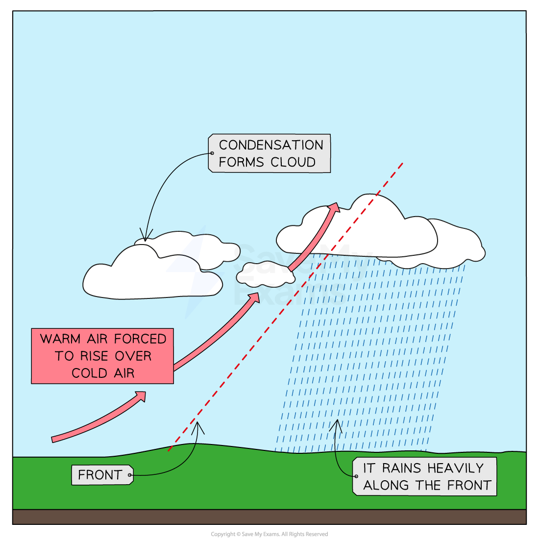
Frontal rainfall
Convectional rainfall
- Convectional rainfall occurs when the ground heats the air above it
- It happens in summer, particularly during a heatwave
- The sun heats the ground, which releases heat, and the air above is warmed
- Warm air rises rapidly, then cools and condenses to form dark rain clouds
- These clouds can produce heavy rainfall and thunderstorms

Convectional rainfall can occur in the UK after a heatwave, where the ground has been heated by the sun
Water stress
- Although the British Isles receives a lot of rain, it is unevenly spread and this leaves parts of the nation under-supplied or water-stressed
- Most rain falls in the north and west, but the greatest water demand is in the east and south due to:
- Higher population
- Agriculture
- Industry
- Some solutions to these problems are:
- Transfer water from wet areas to drier areas via a pipeline
- Water from North Wales is piped to Liverpool
- Construction of new reservoirs to capture and store water in the east
- Ardingly and Arlington reservoirs in Sussex supplies stores 8,300 million litres of water
- Water conservation through repairing leaking pipes, encouraging people to use less water and installing water meters in all new homes
- Transfer water from wet areas to drier areas via a pipeline

