Urban Precipitation (AQA A Level Geography)

Revision Note

Test Yourself
Jacque Cartwright

Expertise

Geography Content Creator

Characteristics of Urban Drainage

  • Urban areas experience higher rates of precipitation compared to rural regions because of:
    • Pollution - urban air holds more condensation nuclei in the form of dust and dirt particulates
    • Warmer air - the warmer the air, the more moisture it holds
  • Surface runoff (overland flow) is dominant as much of the surfaces are impermeable or designed to shed water - the camber of a road, funnels water to drains
  • There is also less vegetation to intercept precipitation, which means less evapotranspiration (EVT) rates to cool the air and reduce humidity
  • As a result, more drainage is needed to remove surface water quickly

urban-vs-rural-runoff

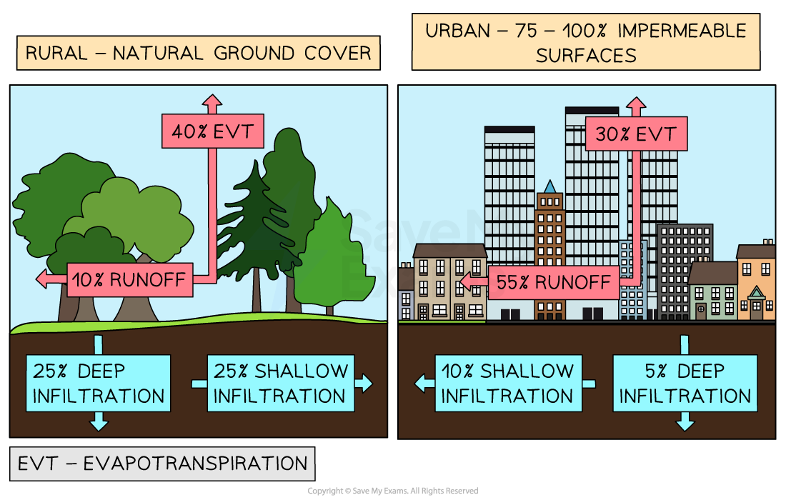
Image showing contrast between urban and rural runoff

Impacts of Urbanisation on Drainage

  • The urban form impacts the drainage system in the following ways:
    • Inputs are increased
      • Precipitation is increased due to pollution and temperature
      • Extra water is artificially imported into the system
  • Outputs are unbalanced
    • Less vegetation reduces EVT
    • Impermeable surfaces increases runoff
    • Wastewater discharge is an adjusted output into a river or sea (sewage discharge is treated but there will still be liquid waste added to the system)
  • Transfers are increased
    • Runoff is contaminated through dust and pollutants from industry and transport
    • Artificial drainage systems are added above and below ground (e.g. guttering and storm drains etc.)
  • Stores are decreased overall
    • Impermeable surfaces reduce ground infiltration and stores are reduced
    • Rivers are diverted, dredged or channelised which increases capacity 
    • Reservoirs and ponds are permanent stores but vulnerable to evaporation
    • Depression (puddles) stores are temporary
    • Lakes and ponds in parks and homes are often drained
  • These changes become more pronounced across the urban pathway, with the urban CBD system seeing the greatest impacts, compared to the rural-urban fringe system

Urban Water Cycle

  • Urban hydrographs are 'flashy'
  • They show a rapid rise in discharge over a short period of time 
    • Short lag time
    • High peak discharge
    • Fast return to base flow
  • Caused by:
    • Low infiltration rates
    • High surface runoff

urban-rural-hydrograph-comparison

Comparison between rural and urban hydrographs - rural hydrographs are 'flat', whereas urban are 'flashy'

flood-hydrograph

  • Flash floods in urban areas are increased through:
    • Heavier rates of precipitation
    • Increased thunderstorms
    • High rates of impermeable surfaces
    • Channelling of surface runoff to drains
    • Building on floodplains to meet demand for housing
    • Culverts, rivers and drains blocked with debris
    • Narrow channels under bridges constricting flow

Exam Tip

  • Practice drawing and annotating or labelling a typical urban hydrograph to help explain how urban areas modify the water cycle.

You've read 0 of your 0 free revision notes

Get unlimited access

to absolutely everything:

  • Downloadable PDFs
  • Unlimited Revision Notes
  • Topic Questions
  • Past Papers
  • Model Answers
  • Videos (Maths and Science)

Join the 100,000+ Students that ❤️ Save My Exams

the (exam) results speak for themselves:

Did this page help you?

Jacque Cartwright

Author: Jacque Cartwright

Jacque graduated from the Open University with a BSc in Environmental Science and Geography before doing her PGCE with the University of St David’s, Swansea. Teaching is her passion and has taught across a wide range of specifications – GCSE/IGCSE and IB but particularly loves teaching the A-level Geography. For the last 5 years Jacque has been teaching online for international schools, and she knows what is needed to pass those pesky geography exams.