Glacial Erosion Landforms & Landscapes (Edexcel A Level Geography)

Revision Note

Jacque Cartwright

Expertise

Geography Content Creator

Glacial Erosion

Sub-aerial weathering

  • Freeze-thaw or frost shattering, happens when rocks contain cracks and where temperatures regularly dip below the freezing point
  • Any water in the cracks will freeze as the temperature drops, which expands as it freezes, exerting pressure on the crack
  • Repeated freezing and thawing of water will eventually break the rock apart and it will pile up as scree at the foot of the slope
  • When trapped under the ice, the sharp, angular rocks are an effects abrasive tool
process-of-freeze-thaw-weathering

Carbonation

  • Is an important process in cold environments and occurs in rocks with calcium carbonate, such as chalk and limestone
  • Rainfall (pH of 5.6 ) combines with dissolved carbon dioxide or organic acid to form a weak carbonic acid solution
  • Calcium carbonate (calcite) in rocks, reacts with the acidic water and forms calcium bicarbonate, which is soluble and removed in solution by meltwater
  • The effectiveness of the solution is related to the pH of the water as carbon dioxide is more soluble at lower temperatures 

Nivation

  • A blanket term for active processes that occur at the edges of snow patches 
  • The processes include the physical and chemical weathering that occur underneath patches of snow
  • Fluctuating temperatures and meltwater promote chemical weathering and freeze-thaw action 
  • Weathered material is transported with the summer meltwater
  • Repeated cycles of melting, freezing, and transportation form nivation hollows
  • Saturated debris (due to summer meltwater), destabilises the slope and slumping may occur 
nivation-process
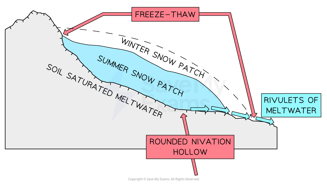
Diagram showing the process of nivation and the formation of hollows

Glacial erosion

  • After glaciers break down the rock through freeze-thaw action, erosion continues the process by plucking and abrasion
  • Plucking:
    • Movement of the ice mass generates friction and heat, causing the base of the glacier to slightly melt 
    • This meltwater freezes around rocks and stones under the glacier
    • As the glacier moves forward, it 'plucks' this ice, pulling the rock away 
  • Quarrying: 
    • Similar to plucking in that pieces of bedrock are transported and eroded within the glacier
    • As a glacier moves through a valley, pressure is exerted on the sides and bottom of the valley
    • Friction causes melting, allowing meltwater to surround the rocks in the valley 
    • As the meltwater refreezes, it pulls on the ice and quarry's the sides of the valley away
  • Abrasion:
    • Abrasion occurs as bits of rocks, stones, and boulders stuck in the ice, grind against the rock below the glacier wearing it away and producing rock flour
    • Striation (scratch) marks arise when rocks beneath the glacier are transported across the bedrock 
  • It is the weight of the ice in a glacier that forces it to advance downhill, eroding the landscape as it moves
  • Ice advances in a circular motion called a rotational slip, which hollows and deepens the landscape
glacial-erosion
Main forms of glacial erosion
  • Crushing
    • This happens when pressure exerted by the ice mass and its debris, crushes the bedrock surface leaving chattermarks fractures as it moves over the bedrock
  • Basal melting
    • As pressure increases, the melting point of water decreases
    • The thicker the glacier, the greater the pressure; the lower the temperature at which water melts
    • As temperate glaciers move down the valley, friction melts the glacier's base
    • This layer of meltwater acts as a lubricant and allows the glacier to 'float' allowing basal sliding and the glacier can move faster
  • Mass movement
    • Can occur quickly with the sudden movement of large ice masses, usually due to basal slipping - ice sheet calving is a good example of mass movement 
  • Processes do not work in isolation or at the same rate, there are continuous adjustments, particularly after glacial retreat; where landforms are not only shaped but reshaped by by the combined action of mass movement, weathering, erosion, and fluvial action

Glacial Erosion Landforms

Glacial cycle of erosion

  • There are 3 stages to glacial erosion
    • Youthful
    • Mature
    • Aged
  • Youthful
    • This marks the beginning of erosional landforms
    • The shaping and hollowing of a corrie by ice
    • The beginnings of aretes and horns
  • Mature
    • Corries are well-formed and begin to meet
    • The glacial valley takes on its ribbon-shaped with a regular, stepped graded contour
    • Hanging valleys are visible
    • The valley floor begins to deepen and takes on the shape of a trough
  • Aged
    • 'U'-shaped valley is clearly defined
    • Development of the outwash plain, including features of drumlins, eskers, kettle holes, etc. 
    • Corries converge, mountain summit heights decrease and their peaks become rounded
  • Erosional landforms are created when moving masses of glacial ice slide and grind over bedrock
  • Glacial ice contains large quantities of unsorted sand, gravel, and rock that was plucked out of the bedrock
  • Ice sliding across the bedrock, grind the debris into a fine, but gritty powder called rock flour
  • Rock flour polishes the surface of the bedrock to a smooth finish called glacial polish
  • The remaining trapped debris and larger rocks, create long grooves, called glacial striations, as they flow over the bedrock
  • These striations indicate the direction of ice flow
landforms-of-glacial-erosion
Landforms of glacial erosion
  • Corrie/cwm/cirque
    • Corrie, cwm and cirques are all the same feature and are deep, pre-glacial hollows of accumulated snow and ice 
    • In Wales corries are called cwms and in France they are called cirques 
    • Found at the apex of a glacial valley, on the coldest aspect of the mountain, with the greatest accumulation of snow and ice
    • As the accumulated ice begins to flow; basal/rotational sliding along with plucking and abrasion, hollows the mountain into a bowl-shape
    • Debris is pushed to the edges of the corrie, which acts as a dam (corrie lip) to the accumulating snow
    • As the ice thickens within the hollow, it flows over the corrie lip and downhill as a glacier
    • Plucking, abrasion and freeze-thaw weathering, steepen the back wall of the corrie, into the familiar armchair shaped landform
    • Examples include Helvellyn Corrie in the Lake District and Cwm Idwal in Eryri National Park (Snowdonia)
  • Arête  
    • Arêtes are knife-edge, steep-sided ridges
    • Formed when two corries cut back into the mountainside 
    • As each corrie glacier erode either side of the ridge, the edges become steeper and the ridge narrower
    • This gives the arête it's a jagged profile
    • Examples include Crib Goch in Eryri National Park, and Striding Edge in Lake District England
  • Pyramidal peak 
    • As the name suggests, this is a three-sided, pointed mountain peak
    • Formed when three or more back-to-back corrie glaciers carve away at the top of a mountain
    • This creates a sharply pointed mountain summit
    • Examples include Yr Wyddfa (Snowdon) in Wales and Buachaille Etive Mòr, Glencoe, Scotland 
  • Corrie, tarn or cirque lakes
    • Corrie, tarn or cirque lakes form when the ice within the corrie melts 
    • Because of the corrie lip at the bottom end, the meltwater is held in place and a circular body of water is formed
    • Examples include Red Tarn, Helvellyn in the Lake District and Cadair Idris in Eryri National Park (Snowdonia)
  • Truncated spur
    • Truncated spurs are past interlocking spur edges of past river action that have been cut-off forming cliff-like edges on the valley side
    • Found between hanging valleys and are an inverted 'V' shape 
    • Formed when past ridges/spurs are cut off by the lower valley glacier as it moves past
    • An example is Nant Ffrancon Valley in Eryri National Park
  • Hanging valley
    • These are small tributary glaciers found 'hanging' above the main valley floor
    • When melting occurs, there are waterfalls onto the valley floor
    • An example is Cwm Dyli in Eryri National Park
  • Ribbon lake
    • As a glacier flows it travels over hard and softer rock
    • Softer rock is less resistant to erosion, so a glacier will carve a deeper trough over this type of rock
    • When the glacier has melted, water collects in these deeper areas
    • This creates a long, thin lake called a ribbon lake
    • Examples include Lake Windermere in the Lake District and Llyn Ogwen in Eryri National Park
    • The areas of harder rock left behind are called rock steps
  • Glacial trough/U-shaped valley
    • Glacial troughs are steep-sided valleys with a flat floor 
    • They start as V-shaped river valleys but due to the size and weight of the glacial ice it changes to a U shape as the glacier erodes the sides and bottom making the valley deeper and wider
    • Examples are found all over the UK, but Nant Ffrancon and Nant Gwynant in Eryri National Park are good examples
    • At the end of the last Ice Age, many coastal troughs (glacial) flooded to form fjords (Norway) or sea lochs (Scotland)

Exam Tip

When explaining the formation of landforms, always follow a clear sequence and refer to named processes rather than generic terms i.e. by transportation or by erosion. State clear links between the processes and its subsequent landform.  

Scouring & Differential Geology

  • Scouring is the ability of the ice mass to erode large areas of pre-existing landscape
  • Occurs when the glacier overspills its containing valley
  • Ice sheet scouring produces the following landscapes:
  • Knock and lochan:
    • These are macro-scale, scoured rugged, lowland features
    • Consist of 'knocks', small rounded hills with no vegetation, and 'lochs' of small lakes
    • Created by the intense erosion of the surface by an ice sheet
    • The knocks are resistant bedrock hills with the lochs being formed by over deepening hollows 
      • Examples are found in the Outer Hebrides, Scotland

knock-and-lochan-2

Knock and lochan formation of the Outer Hebrides, Scotland

  • Crag and tail:
    • A macro-scale, tapered ridge of glacial deposits, extended to one side, found in both upland and lowland areas
    • Formed when a ‘crag’, a large section of hard, resistant bedrock e.g. volcanic rock, protects a section of softer, unconsolidated material, the ‘tail’
    • The advancing ice sheet is forced to go around the upstream or stoss section of resistant rock (crag), leading to melting and refreezing around loose rocks and boulders, which are plucked as the ice mass moves forward
    • The leeward or downstream side of less resistant material is protected directly behind the crag
    • Velocity and pressure is reduced and deposition occurs
    • As the ice mass continues, abrasion of the softer rock occurs and the tail is drawn and smoothed by abrasion with the plucked crag debris
      • Example is Castle Rock (crag) and Royal Mile in Edinburgh (tail)

crag-and-tail

Crag and tail formation of Edinburgh's Castle Rock and Royal Mile

  • Roche moutonnée (sheep's back)
    • A meso-scale, resistant, bare mass of rock, on the valley floor, that has been sculpted by flowing ice
    • Reversed crag and tail, with plucking occurring on the leeward side and smoothing on the upstream, stoss side
    • The upstream or stoss side of the outcrop, is smoothed due to abrasion by the glacier
    • The moving ice leads to localised pressure melting
    • This eases basal sliding and increases erosion over the rock, creating striations across the top of the rock
    • On the leeward or downstream side, the pressure reduction refreezes the meltwater
    • This bonds the base of the glacier to the outcrop
    • As the glacier continues to flow, loose rocks/boulders are plucked out and a jagged, steep surface is left behind
Formation of roche moutonnée 
Formation of a roche moutonnée (sheep's back)

Differential geology

  • This is the differences in geology that contribute to the landforms that are generated by processes in glaciated landscapes
  • It is the orientation, structure, and pattern of the bedrock that has a major impact on the scale and type of erosional landforms
  • For example:
    • It is the pattern and orientation (direction) of resistant to less resistant rock that creates 'knock and lochans', rather than physical ice processes
    • With a crag a tail formation, it is the sheer size of resistant rock that forms the steep, upstream stoss which protects the soft, leeward rock by reducing velocity and pressure of the ice mass as it passes over
    • A sloping tail forms as the protection deteriorates with distance

You've read 0 of your 0 free revision notes

Get unlimited access

to absolutely everything:

  • Downloadable PDFs
  • Unlimited Revision Notes
  • Topic Questions
  • Past Papers
  • Model Answers
  • Videos (Maths and Science)

Join the 100,000+ Students that ❤️ Save My Exams

the (exam) results speak for themselves:

Did this page help you?

Jacque Cartwright

Author: Jacque Cartwright

Jacque graduated from the Open University with a BSc in Environmental Science and Geography before doing her PGCE with the University of St David’s, Swansea. Teaching is her passion and has taught across a wide range of specifications – GCSE/IGCSE and IB but particularly loves teaching the A-level Geography. For the last 5 years Jacque has been teaching online for international schools, and she knows what is needed to pass those pesky geography exams.