Quantitative & Qualitative Skills (AQA A Level Geography)

Topic Questions

1
Sme Calculator
6 marks

Figure 1 shows rainfall data, a measured hydrograph and a simulated hydrograph for Taguibo Watershed in Mindanao Island, southern Philippines. The data were collected from 13 to 17 April 2007. The simulated hydrograph is a computer-generated prediction of discharge.

Figure 1

fig-1-paper1-june2019-aqa-alevel-geography

b)
Analyse the data shown in Figure 1.
[6]

Did this page help you?
2
Sme Calculator
6 marks

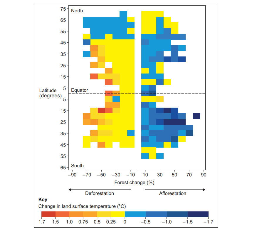
Figure 1 shows the impact of different rates of deforestation and afforestation upon land surface temperature (LST) at different latitudes. The data was collected between 2000 and 2011.

Figure 1

The impact of different rates of deforestation and afforestation upon land surface temperature (LST) at different latitudes. The data was collected between 2000 and 2011.

fig-1-inserts-paper1-nov2021-aqa-alevel-geography

b)
Analyse the data shown in Figure 1.
[6]

Did this page help you?

3
Sme Calculator
6 marks
Figure 1 shows change in greenhouse gas (GHG) emissions, grouped by relative wealth of country, between 1970 and 2010.
Figure 1
fig-1-paper1-june2018-aqa-alevel-geography
b)
Analyse the data shown in Figure 1.
[6]

Did this page help you?